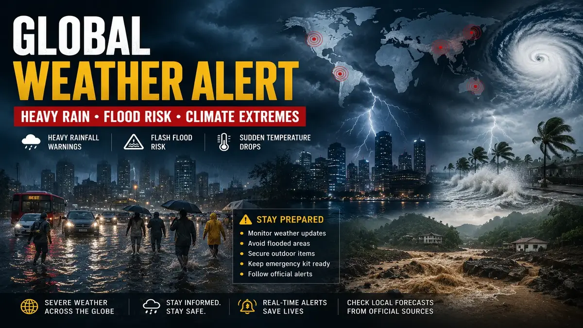
Global Weather Alert: Heavy Rain Warnings and Climate Extremes Put Millions on Watch
A dramatic shift in global weather patterns is drawing urgent attention from meteorologists and emergency agencies worldwide. Multiple regions are experiencing unusual rainfall events, severe thunderstorms, flash flood warnings, and rapid temperature fluctuations — disrupting daily life and raising serious concerns. At the centre of this volatility: a rapidly developing El Niño confirmed by the World Meteorological Organization (WMO), now pushing weather systems to new extremes.
🌡️ Why Weather Patterns Are Becoming More Extreme
Scientists point to a combination of natural climate variability, warming oceans, and increased atmospheric moisture as key drivers behind recent weather events. The WMO's June 2026 seasonal update confirms that above-normal sea-surface temperatures are now dominating large portions of the equatorial Pacific, Indian Ocean, and tropical Atlantic — all feeding atmospheric instability.
A warmer atmosphere holds more moisture, which transforms routine weather systems into significant flooding events within hours. Meteorologists are closely monitoring several developing systems with the potential to produce intense rainfall, strong winds, and localized flooding across multiple regions simultaneously.
🌊 Flash Flood Risks Continue to Rise
One of the biggest concerns associated with current weather patterns is flash flooding. Unlike river flooding, flash floods can develop rapidly with little warning. Urban areas are particularly vulnerable because large amounts of rain falling over short periods can overwhelm drainage systems. In San Antonio, Texas, a single storm recently shattered a 132-year-old daily rainfall record — a reminder of how fast conditions can deteriorate.
- ! Streets can become impassable within minutes of heavy downpours
- ! Underpasses and low-lying roads are especially dangerous — avoid them
- ! Vehicles account for the majority of flood-related emergencies
- ! Localized flooding may occur even when nearby areas appear dry
- ! Flash Flood Emergency declarations signal catastrophic threat to human life
→ Full NWS Flood Safety Guide
🌡️ Sudden Temperature Swings Surprise Forecasters
Another unusual trend being observed globally is the occurrence of rapid temperature changes. Several regions that recently experienced intense heat have seen temperatures fall dramatically following the arrival of strong storm systems. The WMO's 2026 reports confirm that above-normal land surface temperatures are widespread across Northern Hemisphere mid-latitudes — setting up volatile swing conditions when cold systems intrude.
- ✓ Powerful wind gusts accompanying front arrivals
- ✓ Thunderstorms developing rapidly along temperature boundaries
- ✓ Reduced visibility on roads during transition periods
- ✓ Increased lightning activity during atmospheric instability
✈️ Transportation Disruptions Expected
Weather-related disruptions remain one of the most immediate consequences of severe rainfall events. Major highways, airports, and rail networks experience delays when heavy rain reduces visibility or causes localized flooding. For commuters, even short-duration storms can significantly impact travel schedules.
- ✓ Check weather forecasts before any departure — update checks 1 hour before travel
- ✓ Monitor airline and rail updates via official apps
- ✓ Allow extra travel time of 30–60 minutes during storm periods
- ! Avoid all unnecessary travel during active severe weather warnings
🌍 El Niño, Climate Change, and the New Weather Reality
While no individual weather event can be attributed solely to climate change, scientists increasingly observe long-term trends toward more frequent and intense extreme weather events. The WMO's State of the Global Climate report confirms that the 2015–2024 decade was the warmest ten years on record — with accelerating glacier loss, rising sea levels, and intensifying extreme weather wreaking havoc on communities worldwide.
The current El Niño, developing rapidly in mid-2026, amplifies these baseline trends. The WMO Secretary-General has stated: the footprint of an El Niño travels far beyond its origins in the Pacific Ocean, impacting agriculture, energy supplies, water resources, and livelihoods across entire regions. Weather is becoming less predictable — with longer dry periods interrupted by more intense rainfall events.
🛡️ How Families Can Prepare Right Now
Preparation remains the most effective defense against severe weather. Even basic steps taken before a storm arrives can significantly reduce risk to life and property.
- ✓ Enable emergency weather alerts on all smartphones — including WMO and national agency apps
- ✓ Keep flashlights, batteries, and emergency food/water supplies ready at all times
- ✓ Charge all essential electronic devices before storms arrive
- ✓ Secure outdoor furniture, planters, and any loose objects that wind can turn into projectiles
- ! Never drive through flooded roads — turn around, don't drown
- ✓ Follow official weather agencies — NOAA, WMO, IMD — for real-time alerts and updates
🔭 What Meteorologists Are Watching Over the Next 48 Hours
- Expanding rainfall zones — Central US
- Flash flood risk areas — Gulf Coast
- Severe thunderstorm development
- Coastal weather systems — SE Texas
- Transportation impacts — major highways
- Temperature fluctuation zones
- El Niño intensification tracking
- Tropical activity — Atlantic basin
❓ Frequently Asked Questions
🏁 Final Verdict
The current wave of heavy rainfall alerts, flash flood concerns, and sudden temperature shifts serves as a sharp reminder that weather conditions can change quickly and with significant impact. With El Niño now confirmed and intensifying, and ocean temperatures running above average across multiple basins, meteorologists expect this pattern of heightened volatility to continue through the second half of 2026.
Whether facing heavy rain, thunderstorms, or localized flooding, staying informed and prepared remains the most effective strategy. Awareness and early action — guided by official sources — can make a critical difference when conditions shift rapidly.